Following the reports and initial surveys of landslip in the area below Duffryn Rhondda, NPTC engaged external consultants to design a refurbishment scheme for the failed or failing sections of gabion baskets at the toe of the embankment slope which supports the Riverside Tip and to examine the 4 culverts under the tip. These Gabion baskets were put in place circa 1980 to protect the tip from the River Afan.
The main works were due to start in the summer of 2022 subject to the design being finalised/agreed & funding however there were delays in finances but these works actually started in February 24. Our club representatives have been invited to a number of site meetings and the contractors “WALTERS” have taken on board our concerns and requests with regards to ongoing disruption and finished product.
The surveys have identified 4 main areas of work, so it will be necessary to create 2 access tracks at present, diagonally across the embankment slopes which are heavily wooded. The access tracks are constructed as part of the main works to allow access to in river work and were started in the 3rd week of January. The tree felling corridor is 5m wide and has been timed so as to avoid the start of the bird nesting season.
NPTC external consultants have been liaising with Natural Resources Wales about the works in the summer which will be in the river. They will also be dealing with the application for the Flood Risk Activity Permits from NRW. NPT Biodiversity Teams have also been involved and helped in the development of the scheme & have been liaising with the local interest groups.
Unfortunately the bank stabilisation needs to be completed. There is no doubt that this work will impact on the fishing in the river but measures have been put in place to reduce the impact on our fishing whilst maintaining fish passage throughout.
The cycle track will also be impacted with heavy machinery but will remain open with manned crossing areas to ensure safety.
We are advised that the scheme is expected to take two years to complete but may encroach into a third year.
Walters the main contractor have very kindly supplied us with drone footage of the areas being refurbished. Please check out the links to the drone footage below.
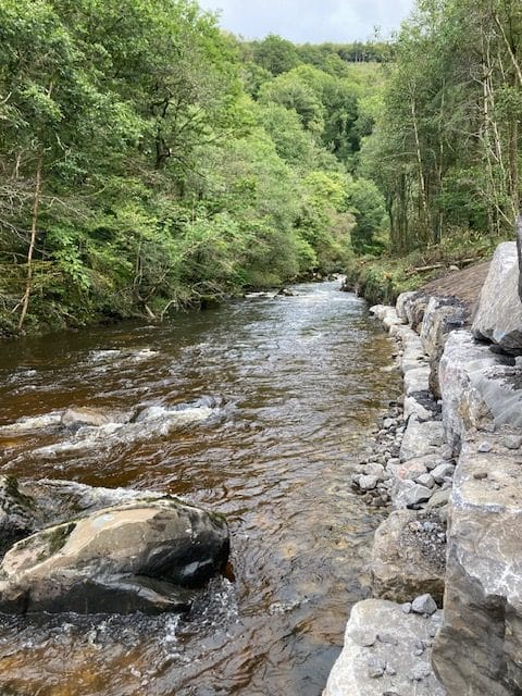
We were invited to visit the site to see the progress made in mid September. We were advised that they had now finished in water work for this year, we had previously been under the impression that funding had been secured for the completion of the project next year, however this may now not be the case. The contractors have now been asked to remove all equipment etc. Walters have prepared areas planned for repair/refurbishment next year but we will now have to wait to find out if they are to complete the initial plan. The work completed to date looks impressive and substantial. During the visit we could see a culvert discharge wall near completion. As requested the contractors had placed large boulders in the main river flow at staggered positions as resting areas for fish and inverts. You will notice in the later pictures, that the banks are covered with a natural netting which will be used for securing and supporting seed and will reduce run off.
Please find below two further links for drone footage taken at the near completion for 2024 season.
11_10_24 Scour Areas 4A & 4B.mp4
In September 2025 the in-water work was completed. There will be ongoing work in the surrounding area to repair fences, roads and cycle tracks which will probably extend into December. The final fly through videos links are shown below.


Update received in February 25 that the funding had been agreed and the work is scheduled to start on site on 17th March 25 with in water work starting 15th April 25. Hopefully the work will be completed this year but there is a possibility that it will run into a third year if necessary. We will of course advise as soon as possible later in the season when details become available. We hope that there will not be too much disruption to fishing but hope that all understand that this will improve the river when completed.
At the start of the project works we had requested and discussed the placement of large stones within the river to provide shelter for fish and invertebrates. In early June 25, we were invited to a site visit to discuss the placement of large boulders by Walters the main contractor and WSP who are river designers who provides a wide range of hydraulic and hydrological modelling solutions for watercourses. We discussed the placement of diamond pattern blockstone where possible using 3 stones closely together some weighing as much as 8 tonnes each. The stones laid with 1 stone upstream supported by 2 behind which will hopefully bed in and remain in the future. The bank stones were also considered. In addition to the already constructed bankstones, there would be additional large stones placed against the bank forming additional resting areas for fish and invertebrates. The project is progressing well but during the winter period it was evident how high the water reached during a November flood. The bank blockstones are stacked 2-3 high which relates to over 2 meters. However during this flood the water topped these stones in places scouring the landscaped surface. Provision was now in place to fit plant and soil stabilisation matting to encourage the route systems to colonise. Old culvert discharges had also been rebuilt which is a huge improvement. Before the work started, the collapsed culverts allowed the leaching of old coal spoil into the river 24/7.


